The transformation in Istanbul affects not only its vicinity but also the Turkey as a whole. Yet, unfortunately the city does not have a stable and holistic upper-scale planning heritage. There are a lot of interruptions, restarts, cancellations and attempts most of which are barely related or even not related at all in the last 40 years of the city’s planning history. In this regard “Istanbul Vision 2050”, as a strategical planning process, will be prepared taking all this heritage into account.
Istanbul is a leading city in economic, social and political terms for not only the Marmara Region, but also for the entire Turkey. All of the developments in Istanbul affect the development of the region. However, for Istanbul and for the Marmara Region, which consists of the city’s area of influence, there is no holistic strategy document or an upper-scale plan addressing this influence with its social, economic, sectoral and physical dynamics. The Marmara Region is divided into five sub-regions according to the Nomenclature of Territorial Units for Statistics in Turkey (NUTS Turkey) Level 2 and the regional plans are carried out in a sustainable manner for every sub-region to enable developing their own resources and potential.
The recent trend that the industry in Istanbul is being moved towards the periphery of the city means new investment opportunities for all the other provinces of the region. Since this trend attracts a new population, it also leads to emergence of social and spatial needs and ecological problems.
At the root of the problems regarding planning in the region, there lies the absence of a holistic regional plan prepared with a strategic approach covering the whole Marmara Region, alongside with the region being a nodal area where the economic sector and employment opportunities are concentrated. Instead of such a holistic plan, separate upper-scale plans (Environmental Plans-EP) with traditional physical planning approach were prepared for the sub-regions –that are determined regionally.
Unrelated Plans
The nearest areas of influence for Istanbul is the region that includes Thrace (Edirne, Tekirdağ, Kırklareli), Eastern Marmara (Kocaeli, Sakarya, Düzce, Bolu, Yalova), Bursa and Balıkesir with Çanakkale and Bilecik provinces. Considering the upper-scale plans prepared for these regions, it is easy to notice that the planning decisions are made according to projections for the industry and the population that will be decentralized from İstanbul. And yet, these plans are uncomplimentary and unrelated to each other in terms of meeting this need. There it is observed a competition between the cities to attract capital and population flow from Istanbul. Accordingly in the plans for the each province or sub-region, decisions are made to attract maximum capital from Istanbul. This is why, the planning processes in Istanbul have direct effects on the neighborhood cities and regions.
The lack of continuity in the Istanbul's upper-scale plans is related to the frequent revisions caused by political reasons and therefore resulting in loss of complementarity. The first long-term spatial strategy document covering the metropolitan area of Istanbul will be the "Istanbul Vision 2050".
Regional plan experiences
Considering the upper-scale plan history of Istanbul, the upper-scale physical plans shaped by cancellation and revision processes since the 1980s and the regional plan experiences that started in the late 2000s come to the fore. Istanbul Development Agency prepared a regional plan in 2010 in order to ensure the appropriate and effective use of resources; to activate local potential; to accelerate regional development and to guarantee its sustainability in line with the principles and policies stipulated in national development plans and programs. With the completion of the Tenth Development Plan in 2013 and the National Strategy for Regional Development in 2015, the need for revision arose in the first regional plan covering the years 2010-2013. The study for the second Istanbul Regional Plan covering the years 2014-2023 was carried out in such a context. The Regional Plan is an upper-scale plan that reveals the socio-economic development trends and potential of Istanbul alongside priority intervention areas and sector targets.
1980: The first upper-scale spatial plan was made
The first upper-scale spatial plan covering the metropolitan area of Istanbul is the 1/50.000 scaled Istanbul Metropolitan Area Master Plan approved on 29.07.1980. The target year of the plan prepared by the Istanbul Master Plan Bureau of the Ministry of Development and Housing is 1995 and its target population is 7.1 million. The purpose of the plan is to protect the historical, cultural and natural resources and to ensure the linear development of the city on the east-west axis in the south.
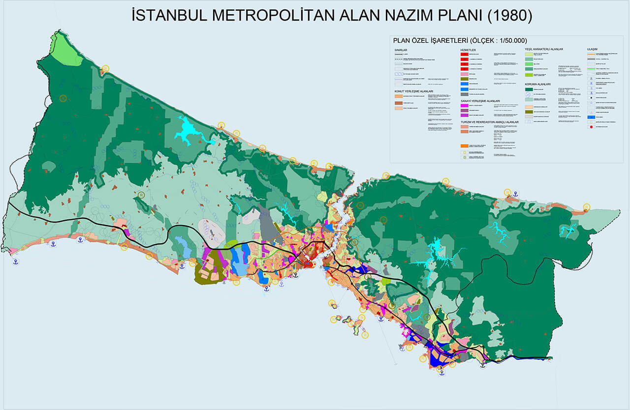
1/50.000 Scaled Istanbul Metropolitan Area Master Plan-1980 *
The plan that was approved in 1980 is the first upper-scale spatial plan of Istanbul.
Click to view the detailed map.
After the establishment of Metropolitan Municipalities in 1984 and authorization for planning was given to the municipalities, a new planning process was initiated. The Istanbul Master Plan Bureau, which prepared the 1980 plan, was transferred to the Istanbul Metropolitan Municipality, and after this date, the efficiency of the bureau decreased as its authority and working order diminished.
1994-1995: The first plan that was cancelled
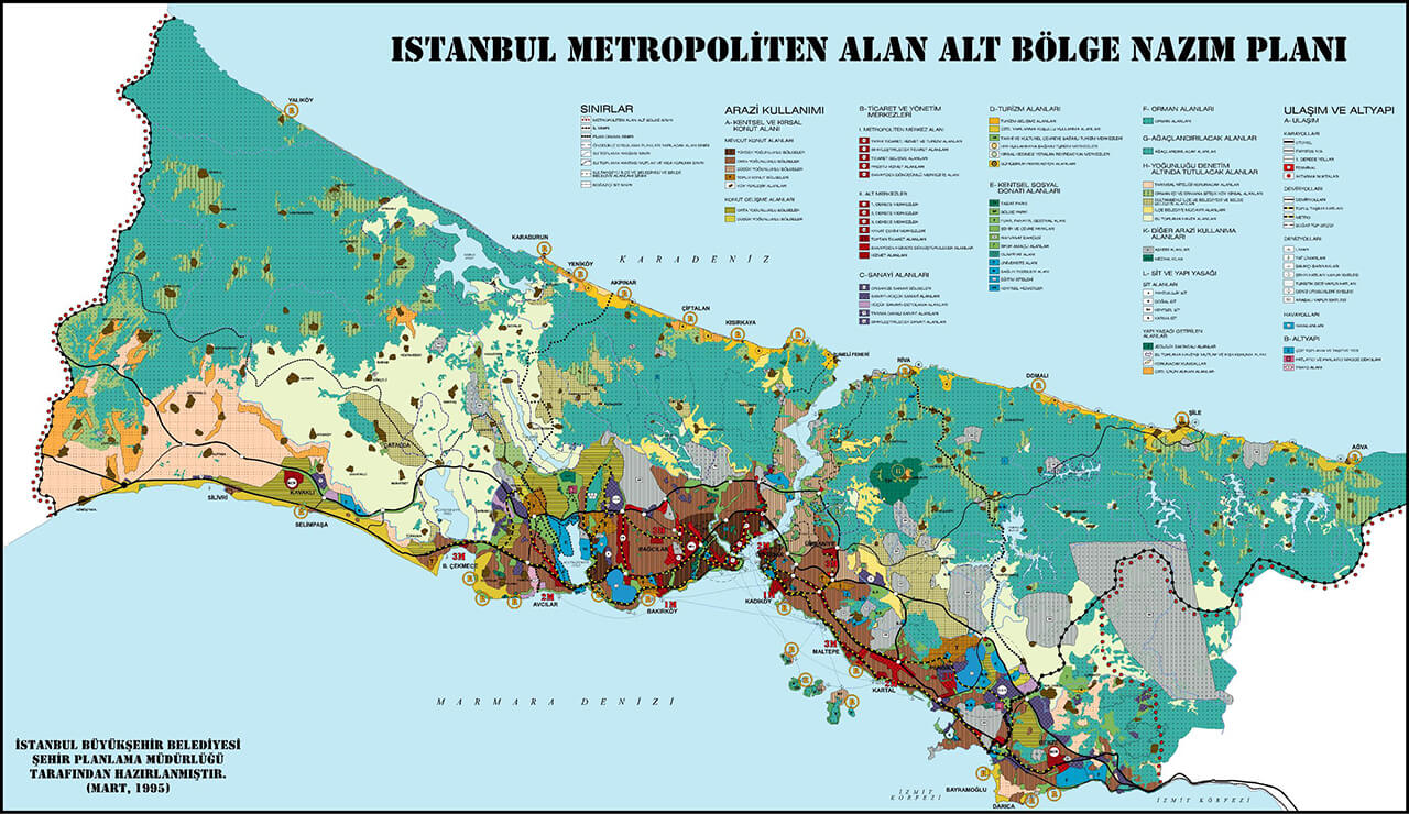
The next upper-scale plan of Istanbul is the 1/50.000 Scaled Istanbul Metropolitan Area Sub-Region Master Zoning Plan approved in 1994. But this plan was not presented to the public and could be revised and approved in 1995 following the local elections of 1994. The plan was made targeting the year 2010 and the population projection for the targeted year was 13 million. This plan was also cancelled in 1999 on the grounds that the Istanbul Metropolitan Municipality was not authorized to make a plan of this scale and it was accepted that the plan prepared in 1980 was legally in effect.
1/50.000 Scaled Istanbul Metropolitan Area Master Plan-1980 *
The population estimate of the 1995 plan, which targets the year 2010, was 13 million.
Click to view the detailed map.
2006: IMP process after 25 unplanned years
With the Metropolitan Municipality Law No. 5216, which was effectuated in 2004, the boundaries of the Istanbul Metropolitan Municipality were expanded to cover the provincial borders. With a protocol signed between Istanbul Metropolitan Municipality (IMM) and the now abolished Ministry of Environment and Forestry, the authority to make and approve environmental plans was transferred to the Municipality. The process of new upper-scale planning within Istanbul Metropolitan Municipality was initiated in 2005 with the establishment of Istanbul Metropolitan Planning and Urban Design Center (IMP). The 1/100.000 scaled Istanbul Provincial Environmental Plan prepared by the IMP was approved in 2006. The population envisaged in the plan for the target year 2023 was 16 million. This plan was also canceled in 2008 due to the lawsuits filed.
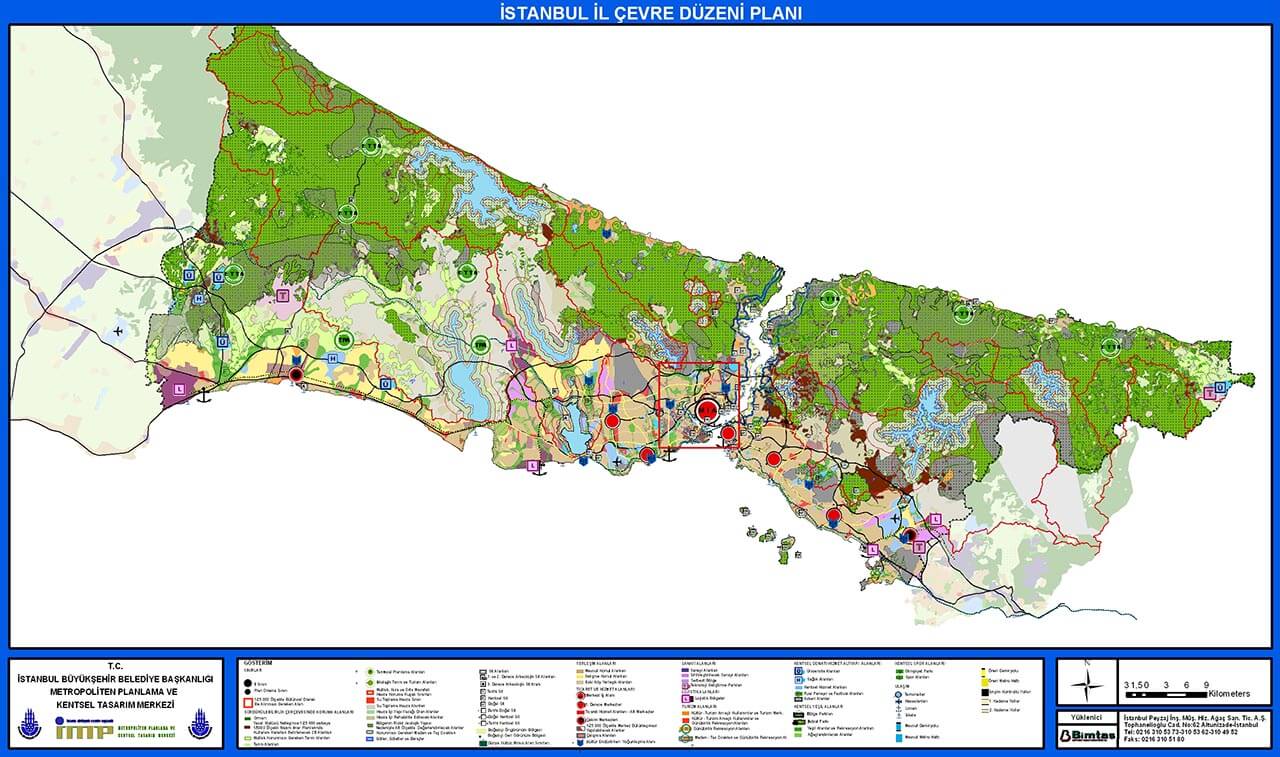
1 / 100.000 Scale Istanbul Provincial Environmental Plan-2006 *
The 2006 plan, signed by the IMP, was cancelled two years later.
Click to view the detailed map.
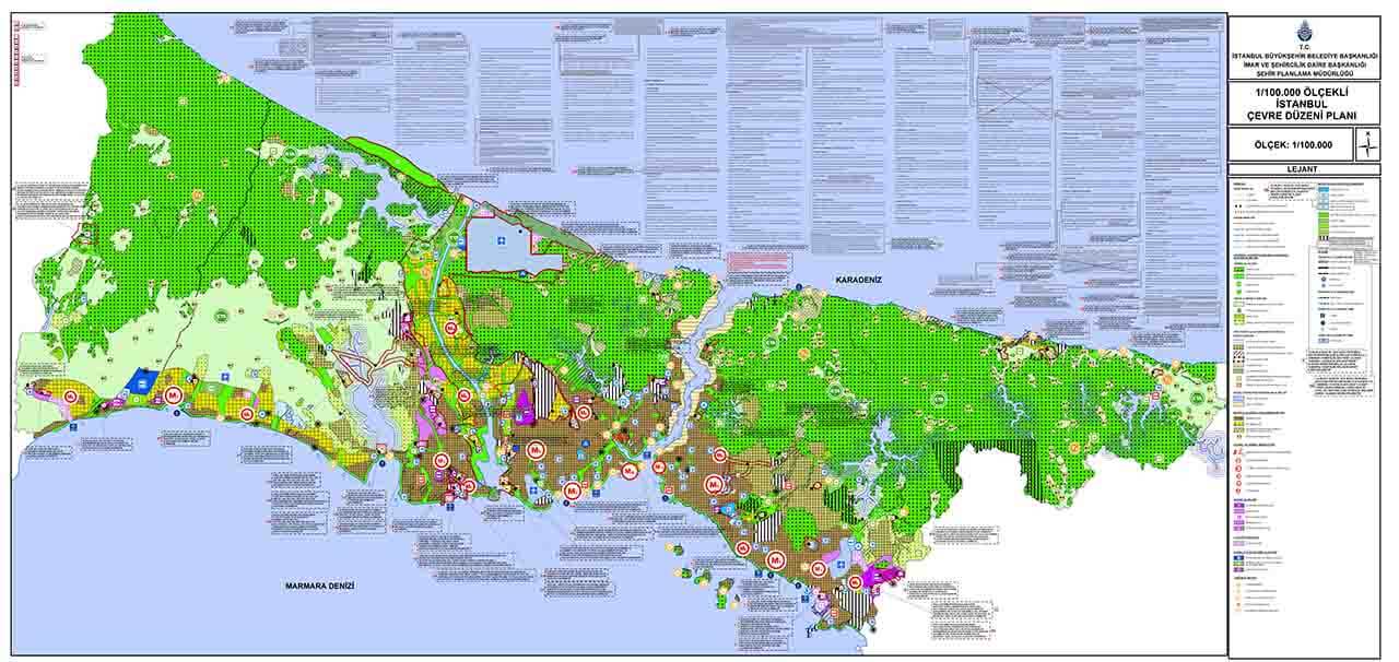
2009: The interventions started immediately after its announcement
After the cancellation decision, the upper-scale plan studies were restarted within the body of IMM Directorate of Urban Planning. The 1/100.000 scaled Istanbul Environmental Plan was approved and was put into effect in 2009. The target year of the plan was 2025 and the projected population was identified as 16 million. However, after it was approved, new project areas were added into the plan with a fragmentary plan decision approach which disrupted the holistic structure of the plan. The original plan had blocked the city's possible extension towards the north. But with added projects some radical disruptions were also introduced such as declaring a sub-region on the north line; for the areas whose agricultural characteristic supposed to be protected, industrial area and logistics center decisions were taken, and new housing decisions for “natural areas that are needed to be absolutely protected” were made. As a result of the determination of “reserve building areas” within the scope of the Law No. 6306 on Transformation of Areas Under Disaster Risk in 2012 and by adding the phrase "waterway" to the law with the amendment made in the Construction Law in 2014, the way has been paved for the construction of mega projects for Istanbul. And the legislative infrastructure has been established for Canal Istanbul, Istanbul Airport (The Third Airport) and Yavuz Sultan Selim Bridge (The Third Bridge). In addition, while the region on Silivri-Gazitepe was designated as a reserve area in 2009 for the Third Airport, with the change made in 2014 the airport was included in the plan to be in its current location on the Black Sea coast. The Third Bridge was not included in the 2009 plan, yet, it was implemented with the "1/25.000 scaled Istanbul Northern Marmara Motorway Master Zoning Plan'' approved on 27.03.2014.
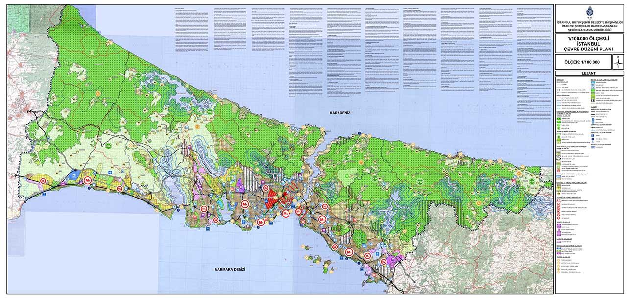
1 / 100.000 Scaled Istanbul Environmental Plan-2009 *
When the 2009 Plan was approved, the mega projects were not on the agenda yet, and Silivri was determined as the most suitable location for the third airport.
Click to view the detailed map.
2017: The failed revision attempt
For the 1/100.000 Scaled Istanbul Environmental Plan Revision which started in 2017, analyses had been made but the revisions are not officially approved yet. The reason for the revision is the changes in the Spatial Plans Construction Regulation and the legislative changes such as the Transformation of Areas Under Disaster Risk numbered 6306. The most recent plan revision made on par with the İstanbul 1/100.000 Scaled Environmental Plan is Province of Istanbul European Side Reserve Construction Area 1/100.000 Scaled Environmental Plan Change, which was prepared by Ministry of Environment and Urban Planning in line with 102nd Article of Presidential Decree No.1 and was approved on 22.06.2020. The main purpose of the plan is to include the controversial Canal Istanbul Project and the "Reserve Construction Area" planned in the surrounding area.
1/100.000 Scaled Istanbul Environmental Plan-2009 * 2020 amended
By 2020, many changes were made on the 2009 plan, and Canal Istanbul Project was included in the plan.
Click to view the detailed map.
Mega infrastructure projects that were constructed although they were not part of the Istanbul Environmental Plan
The unplanned major projects (Third Airport, Third Bridge, The Open Roads, Canal Istanbul) threaten the most valuable ecological assets and water resources of the city, disrupt the population and equipment balance of the plan and invalidate the sub-center predictions.
These decisions, which intervene directly to the plan and disrupt the integrated macro form of the city, are implemented by eliminating the decision-making processes involving all Istanbul residents, especially local administrations. On the contrary, with Istanbul Vision 2050 study, a new planning approach has been adopted and a transparent model will be implemented where decision-making processes take place with democratic participation. At this point, spatial development strategies that will affect the entire Marmara Region will be put forward with this study to be carried out with the strategic plan approach.